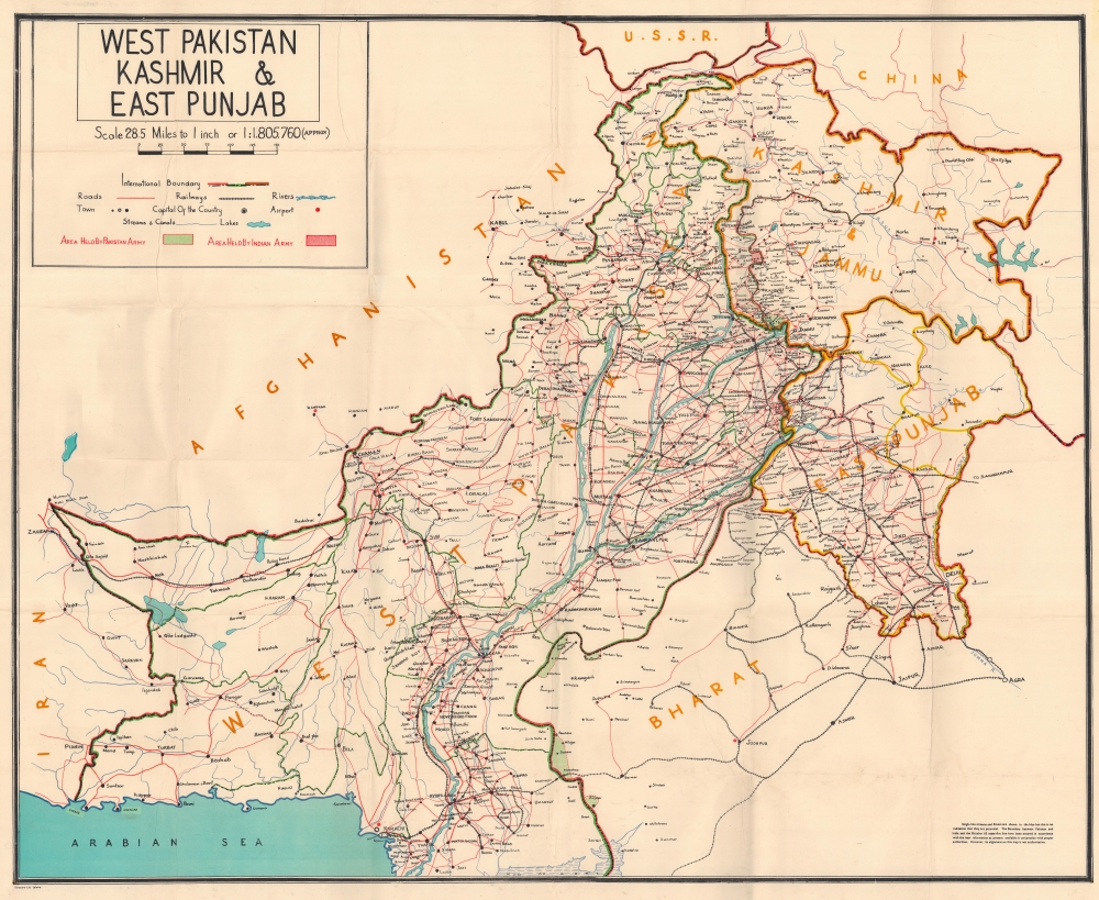
One of the most interesting conversations to come out of the occupation of Palestine for me has been the discussion around borders and the Nation State. Identity politics has always been a feature of my life as a Brown British woman. My parents are from “azad” (meaning free) part of Kashmir, which is governed by Pakistan whilst the other half of Kashmir, called Jummu, is under the control of India. Since the partition of India, and the creation of Pakistan in 1947, when the British drew their line on a map and created one of the most controversial and militarised borders in modern history, both India and Pakistan have laid claim to this land, which has a Muslim majority, and have consistently fought over it. Kashmir is just one of the many examples of borders drawn by the British, with their intention to create long-term animosity in the various regions they once governed, in order to ensure instability and a continuation of their “divide and rule” ambitions.

Despite being born in the UK and having parents who grew up here (my dad came here when he was 15 and my mum when she was 20) by virtue of my brown skin I am never really considered British. Other than regular family holidays I have very little affiliation with Pakistan, my entire identity has been forged by my life in the UK. My partner is Bengali so our children are a mix of Pakistani, Bengali and British, but mostly the latter as neither of us are especially versed in the culture and traditions of our grandparents. But again, because of their beautiful brown skin they to will always find themselves othered in the UK. In a world without colonialism, we would have all been Indian and living in the richest country in the world (in the 1700’s India was worth around $21 trillion dollars and its economy was so large that it was bigger than all of Western Europe combined). If the British hadn’t plundered and pillaged our lands, stolen resources to fund their own industrial revolution, perhaps things would have been different, but as it stands, because they went there, I ended up here!
Nation states and their borders are a relatively new construct. There are different types of borders, natural ones that divide territories by natural landmarks such as the border between France and Germany marked out by the Rhine River or the French Spanish border, which largely follows the Pyrenees mountain range. In contrast to this there are also geometric borders. These are borders that often have straight lines and don’t follow any natural landscape. These are often drawn in due to treaties rather than specific features in nature. You’ll find these borders are especially common in the post colonial world. For example if you look at a map of Africa you’ll notice that many of the 54 countries have completely straight lines. Africa was literally carved up by European leaders in 1885 at the infamous Berlin Conference. The lines they drew had little to do with the natural, cultural or historic context of the land and its people and everything to do with colonial powers and their thirst for resources and power. This lack of regard and knowledge of the land is perfectly demonstrated by Lord Salisbury, then British Prime Minister when he said: “We [the British and the French] have been engaged in drawing lines upon maps were no white man’s foot ever trod: we have been giving away mountains and rivers and lakes to each other, only hindered by the small impediments that we never knew exactly where the mountains and rivers and lakes were“. These artificial borders led to economic hardships and social inconveniences. They prevented communities from moving freely and also divided communities along tribal and ethnic lines. Forced assimilation and direct rule created further tensions and led to conflicts that only strengthen the colonial powers.
The borders drawn by colonial powers were never representative or even considerate of cultures, traditions or ethnicities. Ethnic groups with shared identities were frequently partitioned whilst those with animosities became a single country. The Gambia for example is the smallest country in Africa, its narrow and long with a small coastal border along the Atlantic ocean. It is surrounded by Senegal along the rest of its borders. Its border reflects the vicious colonial ambitions of the French, Dutch and British to control the resources of that nation, including the slave trade. The frequently fought over access points such as rivers, provided them with deeper routes into the continent. Britain’s control of the mouth of the river Gambia allowed them to travel, trade and enslave the local population to the Americas. In 1891 when a boundary commission arrived to map the boundary it encountered local resistance who didn’t recognise their authority or legitimacy to map their territory. The local Gambian resistance successfully compelled them to retreat but they returned with the British military who forced the region into subjugation through violence! The boundaries that were drawn are very similar to the ones that exist today but they don’t reflect the ethic or cultural identities that exist on the ground.
The creation of the nation state is almost entirely an artificial construct. Creating a state that is moulded together into a single entity encouraged to share a national identity has not only been a violent process but one that was born from colonialism and one that continues to benefit colonial interests. If we look at any of the wars taking place across the globe in recent times, (Sudan, Yemen, Syria, Afghanistan and Iraq) all of them have to do with borders that were imposed on them by imperial powers. Iraq is an example of how the British carved out a country with their own interests in mind and no consideration for the people of the region. The three main ethnic groups, The Kurds, the Sunnis and the Shias, were divided in such a way that certain sects were given power over others therefore ensuring regional tensions and disharmony. These internal conflicts kept the country destabilised allowing the British, and others, to exploit their resources. So many of our current global alliances depend on colonial powers dangling carrots to leaders of states they once colonised and whose instability they played a key role in. Whilst they may no longer have boots on the ground they control economies through loans and military funding as well promises of alliances into international spaces developing nations are usually excluded from. Just look at countries like Pakistan and Egypt, both of whom have had their democratic processes interrupted by imperial powers (The United States) because the democratically elected leaders refuse to bow to American demands. The Durand Line, marking the border between Afghanistan and Pakistan, is another line drawn by the British to ensure regional tensions and division of the Pashtuns into two separate countries. The Pashtuns who were at one time fighting the Punjabis in what would become Pakistan, found themselves being ruled by them once the line was draw. These boundaries were not unintentional as we continue to see who benefits from the instability in these regions.
Borders are inherently violent and with increasing nationalism, becoming even more so. Just look at the US Mexico border. When Mexico declared independence from Spain in 1821, the country’s territory included California, New Mexico, Arizona and Texas. In 1836, white Americans moved to Mexico and essentially ethnically cleansed that region and formed The Republic of Texas, which the US annexed in 1845. Prior to that, Mexicans lived, travelled and worked regularly across these areas. After the Mexican-American War, the 1848 Treaty of Guadalupe Hidalgo transferred 55 percent of Mexico’s territory to the United States, establishing (more or less) the same borders that the countries have today. People across the globe, throughout history have travelled for a multitude of reasons, and crossing borders has never been as dangerous as it is today. In fact borders have not only become more militarised, they have also become big business and thus exploitative. In the US for example GEO group is one of the largest private prison providers, and one of its subsidiaries donated $225,000 to Donald Trumps presidential campaign. When the Trump administration launched a zero-tolerance immigration policy, it was these same donors who stood to make billions out of his racist policies. The British Government continues to award contracts to G4S, who beginning in 2002, worked with the “israeli” Occupation Forces to manage “israels” occupation of the West Bank. In 2006 it was G4S who took charge of the checkpoints that controlled the movements of the Palestinians. Although G4S terminated their contracts with “israel” they continue to provide private prisons in the UK and across the globe and they are notorious for shady and controversial practises.
Interestingly, the settler colonial state of “israel” has never fully declared its borders. This isn’t because it believes in a world of free movement and that all people are equal citizens and not aliens as some would like us to believe, because we know it operates an apartheid system and is essentially a theocratic state as it believes it has a God given right to occupy and colonise another peoples land (so can we all please stop calling it the only democracy in the Middle East {insert eye roll}). The occupation has never declared its borders because it has nefarious intentions of occupying even more of the land beyond Palestine, as it did during the 6 day war in 1967. Many of the countries we now know of in the Middle East only came about after the First World War. Both the British and the French had stakes in this region and with the collapse of the Ottoman Empire, they wanted to secure their interests. Post World War 2 the landscape changed again. Britain began to pull out of the Arabian Peninsula in the 1960’s. It withdrew from Kuwait in 1965, Aden protectorate (Yemen) in 1967, Muscat and Oman in 1970, and from Qatar, the Emirates and Bahrain in 1971. Syria and Lebanon gained independence from France in 1943, two years before the end of WWII. The Kingdom of Saudi Arabia was formed in 1932. Almost all of these borders and countries were formed because of colonialism.

Borders demand conflict because they are artificial constructs that benefit very few people, the same people who grow rich selling arms and setting up private prisons to protect them. The free movement of people is an ancient tradition, and opening borders will only increase labour market participation, allowing all people access to opportunities they may otherwise be denied. Currently this movement is controlled by increasingly right-wing governments who have been using immigration to dehumanise and marginalise certain communities. Borders are disproportionately harmful to women and children, whether that’s due to them crossing them “illegally” (which many are forced to do to flee conflicts at home) through human traffickers, crossing large bodies of water in unsafe conditions, or being detained in Immigration Removal Centres (IRC). Sexual violence is common as many of these places are completely off grid and due to the vulnerable status of those seeking asylum. A former detainee from Yarl’s Wood IRC made headlines in 2014 when she reported that guards used CCTV blind spots to sexually assault women, including one woman who had become pregnant. It was also claimed that guards would promise young girls help with their cases in exchange for sexual favours. In 2014, Rashida Manjoo, The UN’s rapporteur on violence against women, was denied access to Yarl’s Wood IRC, from the highest levels in the Home Office, to investigate allegations of sexual assault. Britain is the only country in Europe that can hold people in detention centres for an unspecified and unlimited time. This is cruel and inhumane process is an administrative one, not criminal therefore migrants and undocumented people are detained at the decision of an immigration official, not a court or a judge.
The UK is a small Island and yet only 8.6% of the land in England is developed. 91.2% of land is non-developed use and the remaining 0.2% being vacant. The top three land use groups were ‘Agriculture’ (63.3%), ‘Forestry, open land and water’ (20.1%), and ‘Residential gardens’ (4.9%). 6.9% of land within the Green Belt is of developed use. (info from April 2021). Mathematically, although not practically, it is argued that the entire worlds population can fit into the US state of Texas. These examples are just to show that the Earth is spacious and plentiful, we have the resources to provide for everyone yet wealth is concentrated in the hands of a tiny, tiny, minority, who also benefit from structural inequality and peddling myths about immigration and borders keeping us safe that simply are not true. The hypocrisy that we have witnessed in the last 7 months as bombs, paid for by tax payers in the West, have dropped on the civilian population of Gaza, and while right wing news outlets, owned by billionaires, continue to convince the most gullible of us that this is some how justified, although the exact same act in abhorrent in Ukraine, is a prime example of how the rules based system we have been indoctrinated into thinking exists, is in fact a complete lie. Sovereign states and their right to protect their borders is arbitrary and depends entirely on the whim of those who once colonised the lands. Those who benefit from war and conflict get to decide who is a terrorist and who is a freedom fighter, which democracy is valid, and which they will forcibly remove. All of the “values” we once held about peace and democracy have been shattered, why then do we allow ourselves to be contained by borders, when the whole Earth belongs to us, and not the 1%.
